Home
> digital-humanities, GIS, Institution-is-University-of-North-Carolina-Charlotte, Learning-logs, Metrics, service-is-evaluating-learning-tools, Visualizations > Mapping of Language Student Locations using Bing Maps
Mapping of Language Student Locations using Bing Maps
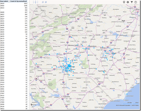
- What do our language students call home? Based on a pivot-table that counts zip codes, let Bing Maps tell you, a default add-in easily accessible in the insert section of the ribbon:

- Note a Limitation: Bing Maps max 100 data points.

- So we limited to zip codes with at least 15 students (which returns just below 100 zip codes).
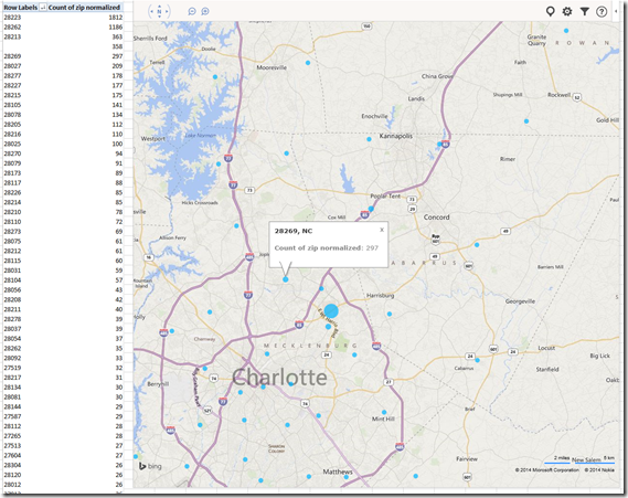
- Also note, the Bing maps app cannot be increased beyond a certain size (below is the maximum).

- Finally, note that the visualization does have a weight indicator, but it seems imperfect:


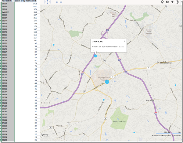
- Here is how data (type) input errors get handled (duplicates override the original):

- Fix your data, the reload from the upper right unfoldable menu:


- Voilà:

Comments (0)
Trackbacks (0)
Leave a comment
Trackback
Blog Stats
- 512,520 hits

Questions? Read the About. Or just ask me a quick
FAQs for LRC student staff or for students or for teachers. To search our FAQs, in the browser addressbar, add after "https://plagwitz.wordpress.com/feed/?tag=faqs+/" "+TAG1" (from tag cloud below) OR "https://plagwitz.wordpress.com/feed/tag=faqs
&category_name=" "CAT1" (from category hierarchy below). OR search both categories and tags, and multiple TAGs/CATs (connect with "," for OR-search, with "+" for AND-search), like so: https://plagwitz.wordpress.com/feed/?tag=TAG1+TAG2+...TAGn&category_name=CAT1
+CAT2+...CATn"
Other ways to find help
If you cannot find it here, look there: 5,500 Language-Learning Links and Programs for learning or teaching 150 languages
Shortcuts:Our Lists, Our Maps, LRC Staff Moodle Site,LRC Project Moodle Site, 49erexpress, UNCC Moodle, Student Recordings: s:claslcslrcsanakostudent
Learning usage samples: Sanako oral exam, Kaltura webcam presentation, Dictation with speech recognition, Sanako written exam, Chinese and Japanese interactive stroke-order practice
Test the Sanako Installer, Webbrowser Popup Konfigurator for XP, or Windows7, faster LRC TeacherPC Log-in Let MS facilitate diacritics writing by installing for you US-International keyboard layout
This is my personal blog (Google+). The views expressed on these pages are mine alone and not those of my employer. The information in this weblog is provided “AS IS” with no warranties, and confers no rights.
Top Posts & Pages
- Bootsect (the command formerly known as fixmbr), may enable your Windows 7 installation to start up from a CorruptVolume
- How to fix “Print to OneNote”, “OneNote cannot find a page on which to insert your printout”
- The base hardware parts of the LRC iMacs
- Use parentheses to search in MS-OneNote for a string that includes punctuation
- If your keyboard stops typing in English in a Respondus lockdown browser quiz…
- Demoing a requirements gathering template for IT project management
- Swift-TX subtitling with Windows XP Japanese IME
- How to fix MS-Word not creating PDF Bookmarks for your Headings
- How to enable a secondary monitor, using the Dell Monitor: Front Buttons
- How to export BMC Remedy data into Excel other than via copy-paste
Top Clicks
7
2007
2010
2011
2013
asset-management
audacity
audio
autoit
blackboard
blogging
c#
calendaring
cameras
FAQs
faronics-deepfreeze
foreign-language-character-input
image2013
image2014spring
imaging
kaltura
langlabemailer
links
lists
live@edu
maps
meeting-requests
metacourses
moodle
mozilla-firefox
MS-Excel
ms-exchange
ms-office
MS-OneDrive
ms-onenote
ms-outlook
ms-powerpoint
ms-windows
ms-windows-7
MS-Word
mstsc
nanogong
nlp
office365
oral-exams
outlook
outlook-live
OWA
permissions
phonetics
recording
resource-mailboxes
resources
Respondus-lockdown -browser
rss
sanako-lab-300
sanako-study-1200
scheduling
screensharing
sdl-trados
sharing
speech-recognition
student.exe
symantec-ghost
text-to-speech
timestretching
trpQuiz
us-international
VBA
video
videos
windows
windows-7
wordpress
xp
Categories
- Area-is-any (194)
- Back office (10)
- Coed432 (2)
- LRCRoomCoed435a (1)
- LRCRoomCoed436 (4)
- COED037 (14)
- presenter-computer (9)
- student-computers (6)
- faculty-offices (3)
- LRCRoomCoed433 (68)
- iMacs (14)
- Listening-Stations (23)
- printer (1)
- Reception-desk (33)
- small-group-work-spaces (12)
- TV-viewing-area (3)
- LRCRoomCoed434 (117)
- Presenter-Computer (78)
- Student-Computers (69)
- MGB-36 (4)
- Back office (10)
- audience-is-any (683)
- Computer and Internet (3)
- Utilities (1)
- Genre-is-any (643)
- announcements (21)
- bad-ideas-and-other-mistakes-samples (1)
- cheat-sheets (2)
- checklists (31)
- documentation (151)
- feedback (2)
- flowcharts (3)
- Internal (1)
- learning-materials (86)
- learning-usage-samples (21)
- marketing (18)
- Notes (228)
- Glitches&Errors (190)
- Learning-logs (24)
- mental-notes (20)
- policies (5)
- Practice&Demos (26)
- conferences (17)
- tradeshows (3)
- projects (9)
- proposals (13)
- reports (11)
- research (2)
- reviews (3)
- step-by-step-guides (38)
- table-of-contents (8)
- training (80)
- clinics (6)
- faculty-showcases (2)
- workshops (29)
- Institution-is-any (193)
- Institution-is-Aston-University (13)
- Institution-is-Drake-University (2)
- Institution-is-London-Metropolitan-University (33)
- Institution-is-Loyola-University-Maryland (27)
- Institution-is-Queen's-University (1)
- Institution-is-University-of-Michigan-Dearborn (3)
- Institution-is-University-of-North-Carolina-Charlotte (120)
- Institution-is-University-of-Tampa (4)
- K12 (1)
- Learning-activity-is-any (82)
- assessments (44)
- assignments (35)
- classroom-activities (8)
- grading (11)
- presentations (4)
- Learning-Tool-is-any (683)
- Classroom-technology (162)
- erepository (19)
- hardware (86)
- audiovisual (28)
- faculty-equipment (10)
- film-studies-equipment (14)
- furniture (1)
- headphones (18)
- mobile-computing (8)
- mobile-phones (4)
- tablets (4)
- phones (6)
- audiovisual (28)
- Media (32)
- multimedia-recording (79)
- software (215)
- Authoring-tools (3)
- Polls (2)
- GIS (4)
- office-software (87)
- Operating-system (20)
- os (16)
- recording-software (15)
- translation-software (9)
- web-browsers (12)
- Authoring-tools (3)
- software-old (7)
- textbooks (22)
- websites (208)
- blog (12)
- eportfolio (7)
- lab-portal (4)
- lms (95)
- Metrics (22)
- Analytics (7)
- Visualizations (8)
- Multimedia-is-any (269)
- animated-GIFs (43)
- Audiofiles (1)
- Charts (8)
- compiledcode (17)
- Documents (15)
- forms (4)
- Interactive-documents (1)
- Photos (11)
- Pictures (1)
- polls (1)
- Scans (2)
- Screencasts (87)
- screenshot-albums (5)
- Screenshots (16)
- Slideshows (24)
- sourcecode (21)
- Spreadsheets (35)
- Videos (13)
- Personal (22)
- second-language-acquisition (249)
- 4-skills (216)
- Grammars (4)
- Proficiency-Levels (36)
- Absolute-Beginner (19)
- Advanced (28)
- Beginner (26)
- Intermediate (29)
- Near-Native (9)
- Syntax (2)
- Vocabulary (52)
- Corpus-linguistics (16)
- corpora (9)
- Dictionaries (18)
- Corpus-linguistics (16)
- service-is-any (454)
- service-is-applying-learning-tools (23)
- service-is-assessing (21)
- service-is-configuring-learning-tools (34)
- service-is-documenting (70)
- service-is-evaluating-learning-tools (38)
- service-is-hr-managing (15)
- service-is-it-managing (20)
- service-is-learning-materials-creation (90)
- service-is-library (99)
- service-is-outreach (2)
- service-is-programming (66)
- service-is-project-managing (16)
- service-is-testing (2)
- service-is-testing-troubleshooting-debugging (71)
- service-is-training (14)
- service-is-tutoring (19)
- Study-program-is-any (314)
- all-languages (228)
- Film-studies (38)
- Interpreting (36)
- Translation (27)
- Teaching-delivery-format-is-any (27)
- technology-domains-is-any (853)
- digital-humanities (7)
- e-commerce (2)
- e-infrastructure (471)
- e-languages (297)
- e-learning (103)
- e-research (2)
- Uncategorized (38)
- unit-is-any (4)
Join 106 other subscribers
Archives
- September 2017
- April 2017
- January 2017
- November 2016
- July 2016
- June 2016
- May 2016
- April 2016
- March 2016
- February 2016
- January 2016
- December 2015
- November 2015
- October 2015
- September 2015
- August 2015
- July 2015
- June 2015
- May 2015
- April 2015
- March 2015
- February 2015
- January 2015
- December 2014
- November 2014
- October 2014
- September 2014
- August 2014
- July 2014
- June 2014
- May 2014
- April 2014
- March 2014
- February 2014
- January 2014
- December 2013
- November 2013
- October 2013
- September 2013
- August 2013
- July 2013
- June 2013
- May 2013
- April 2013
- March 2013
- February 2013
- January 2013
- December 2012
- November 2012
- October 2012
- September 2012
- August 2012
- July 2012
- June 2012
- May 2012
- April 2012
- March 2012
- February 2012
- January 2012
- December 2011
- November 2011
- October 2011
- September 2011
- August 2011
- July 2011
- June 2011
- May 2011
- April 2011
- March 2011
- February 2011
- January 2011
- November 2010
- October 2010
- September 2010
- August 2010
- July 2010
- May 2010
- April 2010
- March 2010
- February 2010
- January 2010
- December 2009
- November 2009
- October 2009
- September 2009
- August 2009
- July 2009
- June 2009
- May 2009
- April 2009
- March 2009
- February 2009
- September 2008
- August 2008
- July 2008
- June 2008
- March 2008
- January 2008
- November 2007
- August 2007
- July 2007
- June 2007
- December 2006
- June 2006
- May 2006
- April 2006
- March 2006
- February 2003
